August 1, 2005
Global Warming and Tropical Storms
There was a report in today's Bellingham Herald:Global Warming Making Hurricanes StrongerYow! This global warming thing is causing stronger hurricanes. We gotta do something... BZZZZZTTTTT!!! Wrong. There are several cycles affecting tropical storms and we are starting into a collection of several of them. Some excerpts from a 2001 article at Science Daily:
Is global warming making hurricanes more ferocious? New research suggests the answer is yes. Scientists call the findings both surprising and "alarming" because they suggest global warming is influencing storms now - rather than in the distant future.
However, the research doesn't suggest global warming is generating more hurricanes and typhoons.
The analysis by climatologist Kerry Emanuel of the Massachusetts Institute of Technology shows for the first time that major storms spinning in both the Atlantic and the Pacific since the 1970s have increased in duration and intensity by about 50 percent.
These trends are closely linked to increases in the average temperatures of the ocean surface and also correspond to increases in global average atmospheric temperatures during the same period.
"When I look at these results at face value, they are rather alarming," said research meteorologist Tom Knutson. "These are very big changes."
Scientists: Future Atlantic Hurricane Picture Is Highly Complexand
In a highly publicized article in the journal Science this summer, a team of meteorologists predicted that the current resurgence in North Atlantic hurricane activity will continue for at least the next 10 to 40 years.
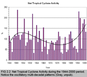
Their findings: The number of hurricanes making landfall in a given year is controlled not only by the long-term, multi-decade trend described in the Science article, but by three shorter-term cycles as well. These four distinct "temporal modes" � each probably the result of a different atmospheric and oceanic phenomenon � combine to determine the number of tropical storms that make landfall each year, Xie and Pietrafesa explain.We have this graph from MESO (Multi-community Environmental Storm Observatory)
20 years of hurricanesand
Meteorologists believe this year's storms part of a cycle started in '95
The record-setting 2004 Atlantic hurricane season has almost two more months to churn up trouble, but it already reminds veteran tropical storm predictor James J. O'Brien of the Wild West.
"It was like ducking bullets from all directions," said O'Brien, director of the Center for Ocean-Atmosphere Prediction Studies at Florida State University in Tallahassee. "The thing that impresses me is that four hurricanes missed me." Tallahassee, located in the state's panhandle, so far has escaped largely unscathed.
"We are a decade into the active phase of a natural 60-year or so cycle of hurricane activity," said Dr. Hugh E. Willoughby, of the International Hurricane Research Center in Miami. "This season is active, but not dramatically more so than others since 1995."Finally, this from the Boston Globe
Hurricanes more powerful, study saysBut... the Globe then went on to check with Dr. William Gray (his chart was used by the MESO paper above)
Researcher at MIT sees larger storms with stronger winds
The destructive power of hurricanes in the North Atlantic and North Pacific has nearly doubled over the past 30 years, at least partly because of human-induced global warming, according to a controversial new study by a prominent climate researcher at the Massachusetts Institute of Technology.
Though the number of tropical cyclones worldwide has hovered at 90 a year for decades, MIT hurricane specialist Kerry Emanuel contends that the storms are growing larger and reaching higher maximum wind speeds than in the past. Focusing on the cyclones that have been most closely measured -- hurricanes striking the Eastern United States and typhoons in Southeast Asia -- Emanuel concluded that today's storms, on average, release far more energy than their predecessors did in the mid-1970s.
"There seems to be a clear correlation" between increasing strength and length of storms and a temperature increase of 0.5 degrees Celsius on the surface of the sea during the same period, said Emanuel, whose paper was published online yesterday by the journal Nature.
One of the nation's leading hurricane forecasters, William Gray of Colorado State University, said Emanuel is leaping to conclusions based on imprecise information about the strength of hurricanes, especially in decades past. He said Emanuel's formula for calculating the energy released by hurricanes obscures the fact that no one directly measured the winds in many of the storms, roughly estimating speeds from satellite images instead.Heh... Posted by DaveH at August 1, 2005 11:38 AM
"It's a terrible paper, one of the worst I've ever looked at," said Gray, who does not believe that cyclone intensity worldwide is increasing. He also questioned Emanuel's contention that human actions, such as the burning of oil and other fuels, have caused the surface of the ocean to warm. Gray said the ocean-temperature increase is natural.
Comments
Post a comment