September 25, 2010
Staring down the barrel of a gun
We are a couple hours away from being royally dumped on. The air is abnormally warm and the humidity is palpable. Perfect conditions for the first... I'll let Cliff Mass tell the story:The First Atmospheric River of the SeasonThe really heavy stuff is going to pass to the north but this is just the forecast and anything goes -- the house is four miles from the Canadian border so it is not that far from the center of excitement. Posted by DaveH at September 25, 2010 7:32 PM
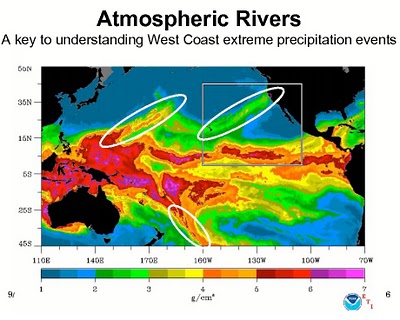
Some of the most important wintertime weather features of our region are the plumes of moisture that stream northeastward out of the tropics and subtropics. In the discipline these plumes are often called "atmospheric rivers" and the atmospheric river that is often discussed in the media is the "pineapple express." This weekend the first major atmospheric river of the season will strike our region, specifically central and northern Vancouver Island and adjacent portions of British Columbia.
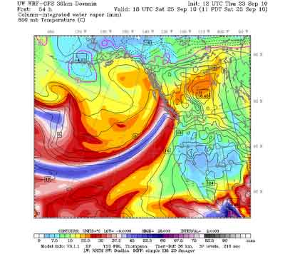
Here is a recent computer forecast of the amount of water vapor in the atmosphere (the fancy name is "column-integrated water vapor"--throw that around and you will impress your friends!) for 11 AM on Saturday. The blues are high values-see the atmospheric river?
The plumes of atmospheric moisture associated with these rivers is usually associated with warm temperatures--in fact it HAS to be that way, because only warm air can hold large amounts of water vapor. When this warm juicy air strikes our mountains it is forced to rise--the result being large amounts of precipitation. Want to see what the models are going for? Here is the forecast 24-h rainfall ending 5 PM on Sunday. The reds are FIVE TO TEN INCHES OF RAIN! There is even a white area, where more than 10 inches is predicted.
Comments
Post a comment